A Few of our Survey Projects
Maryland Chesapeake Bay Oyster Reef Restoration Project Before- and After-Placement Surveys
Harris Creek, Talbot County, Maryland
Little Choptank River, Dorchester County, Maryland
The State of Maryland has embarked on a multi-year project to help restore the native oyster population at a number of locations around the Chesapeake Bay. A team of federal and state agencies, nonprofit organizations, and academic institutions are involved with the restoration site selection process and the reef construction, seeding, and monitoring. Fossilized oyster shells from quarries in Florida are transported by train to the Baltimore Harbor where they are transferred to barges. Tugboats then tow the barges to pre-determined locations where the fossilized shells are placed on the bottom to form new oyster “reefs”. Oyster larvae, or “spat”, is distributed over the reefs, hopefully, leading to the successful growth of native oysters. This is an on-going project that will continue into the decade.
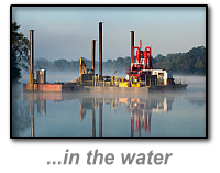
GEOmatx is providing third-party placement surveys to the marine contractor, Corman Marine Inc., to monitor and measure the reef material placed. Using both our 4.5m Zodiac inflatable and 22 ft. C-Hawk Pilothouse workboat, our personnel have conducted surveys at 36 locations on Harris Creek and the Little Choptank River. Starting in January 2014, before-placement surveys have been conducted to establish baselines for measuring the depth of fossilized shells placed on the creek and river bottom. Once in place, after-placement surveys are performed and the differences between the surveys are compared using HYPACK DIF files. The contract tolerances have required modifying standard hydrographic survey practices to insure accurate and “repeatable” measurements.
US Coast Guard Still Pond Station Pre- & Post-Dredge Surveys for Entrance Channel & Boat Basin
Kent County, Maryland
US Coast Guard Station Still Pond is a small boat station within the US Coast Guard's 5th District on Maryland’s Eastern Shore. The Coast Guard Station is on the north side of the entrance to Still Pond Creek and features a turning basin, pier, floating dock and a fueling station for the Coast Guard’s 25-foot Response Boats.
Contract specifications required that the dredging contractor hire a third-party licensed surveyor to perform the required hydrographic surveys. GEOmatx conducted the surveys to measure the quantities of dredged material removed to maintain the entrance channel and turning basin to the US Coast Guard Station. Because tidal currents exceed four knots, surveys were only performed at times of slack tide in the narrow entrance channel. GEOmatx’s 4.5m Zodiac-based hydrographic survey system was ideally suited to the maneuvering in the narrow channel. A Real-Time-Kinematic GNSS survey system provided sea level corrections to the soundings. Survey data was collected and edited using HYPACK Survey and MAX software. Digital terrain models of the pre-dredge channel bottom and post-dredge channel bottom were compared to compute the final payment quantities.
Ronald Reagan Washington National Airport, Runway 15-33 Safety Area Enhancements
Washington, District of Columbia
In 2013/14 the Metropolitan Washington Airports Authority extended Runway 15-33 into the Potomac River. Improvements made as part of this project are intended to provide an enhanced measure of safety for aircraft taking off from and landing on the runway. Stone revetments were constructed on top of the river bottom and filled with compacted sand as a bed for the extended runway concrete.
GEOmatx conducted the pre- and post-construction surveys of the river bottom for Archer Western, the prime contractor. This project required coordination with airport security and surveys could only be scheduled during runway closings at night and on weekends at times of high tides. Surveys were performed utilizing our 4.5m Zodiac survey skiff. It is equipped with floodlights for night surveys and warning lights as a safety precaution. A Real-Time-Kinematic GNSS survey system provided horizontal and vertical positions on Airport datum. Survey data was collected, edited and final drawings were prepared. An additional survey was performed to prepare an accurate navigation chart to guide the contractor’s barges as they maneuvered from the main channel between sandbars to the construction area. At the end of the project, a side scan sonar survey was conducted to locate hazardous rock piles created by spillage from the construction barges. These were then removed for the safety of boats using the Potomac River for recreation and tourism.
Sparrows Point Shipyard Existing Conditions Survey for Entrance Channel, Turning Basin and Piers
Baltimore Harbor, Baltimore, Maryland
Operating as a shipyard since the 1880’s, the Sparrows Point Shipyard was originally part of the larger Bethlehem Steel facility. The current owner, SPS Limited Partnership, maintains active shipbuilding and repair operations. Located outside of the Inner Harbor, this marine terminal is the largest privately held shipyard in the Maryland portion of the Chesapeake Bay. The 226 acre site includes numerous buildings, piers and a graving dock.
GEOmatx personnel have conducted two existing conditions survey of the entire area surrounding three piers, a graving dock, the turning basin and the entrance channel. Depths were measured using an Odom dual-frequency single beam echosounder with differential GPS. Due to the physical constraints caused by the piers, our center-console 4.5m Zodiac boat was used as the mapping vessel. HYPACK Survey was used for navigation control and to record raw data. Once back in the office, raw data was reviewed and edited using HYPACK MAX software. The sorted data files were then used to prepare final planimetric drawings in CADD. Color renderings were used to assist in visualizing the various depths of water in the shipyard.
Multi-Beam Sediment Siltation Survey and Profiles
Brighton Dam, Montgomery County, Maryland
Duckett Dam, Prince George’s County, Maryland
The Washington Suburban Sanitary Commission owns and manages the sewer and water supply system serving Montgomery and Prince George’s Counties in Maryland. Triadelphia Reservoir (created by Brighton Dam) and Rocky Gorge Reservoir (created by Duckett Dam) are two of the agency’s water supply reservoirs and are both on the Patuxent River. They each have a surface area of approximately 800 acres and their depths at the dam face are 60 feet and 90 feet, respectively.
GEOmatx was contracted to provide multi-beam hydrographic surveys along the face of each dam. The new surveys were compared to the previous surveys to quantify the sediment accumulation at the base of the dam. Past surveys were conducted by a team of divers including rescue divers using rope lines, weighted tapes and depth gauges. Using a multi-beam scanning sonar system with positional input from a RTK GPS receiver and a dynamic MRU for three-axis corrections, GEOmatx produced cross-sections every 10 feet perpendicular to the face of the dam and extending upstream 50 feet. After processing and analysis using HYPACK software, drawings and three-dimensional images were produced from the survey data. Elevations were noted at 5-foot intervals. Comparisons to the past surveys proved very difficult due to inaccuracies caused by the previous methodology. However, the multi-beam surveys will provide an excellent baseline for future comparisons.
Pre-, Interim and Post-Dredge Surveys including Dredged Material Quantity Computaions
Lake Elkhorn and Lake Kittamaqundi, Columbia Association, Columbia, Maryland
Lake Elkhorn and Lake Kittamaqundi are man-made reservoirs that are maintained by the Columbia Association in Columbia, Maryland. Constructed in the early 1970’s, they support recreational activities as well as functioning as storm water runoff impoundments. As a result, they accumulate significant amounts of sediment from the surrounding drainage area. In 2012, the Association began a substantial, and costly, effort to remove sediment from the two lakes by hydraulic dredging.
GEOmatx was contracted as a third-party surveyor to provide pre-, interim, and post-dredge surveys. Interim surveys were conducted twice a month due to concerns over changing quantities from summer storms. Depths were measured using a single beam dual frequency echosounder with real-time kinematic GPS. Data was recorded and processed using HYPACK software on a laptop computer. Raw data was edited using HYPACK MAX and cross-section drawings were prepared in CADD. Digital terrain models (DTM) were developed to perform quantity calculations for payments to the contractor.
Home | Hydrographic | Land | Telecommunications | Projects | Contact Us
Copyright © All Rights Reserved.

443.562.7136
survey@geomatx.com


