 |
|||
 |
 |
 |
|
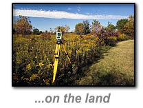
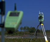
Land Surveys
|
GEOmatx offers a full range of quality geodetic and land survey services to the civil engineering, land development, utility and geo-environmental sectors as well as to Federal, State and local agencies. Through an integrated approach to the measurement, analysis and management of locations and descriptions of geo-spatial data, we develop geomatic data utilizing global positioning systems (GPS) and ground-based instrumentation along with state-of-the art software and information technology for reduction, processing and presentation. GEOmatx has the capability and capacity to provide the quality of service required for the most stringent, client-specified standards for survey operations and map preparation. Our staff is knowledgeable in FGCC and National CAD Standards, state specifications and professional association requirements. |
Our Services include: • Boundary Surveys |
 |
The Legacy of Surveying, “Yesterday’s Dream is Today’s Reality” |
 |
Description of Services:
Perhaps the most important service provided by the professional land surveyor is the boundary survey. A properly executed boundary survey is the basis for every successful land development and/or transaction. This survey will relate the calls in the subject deed to the monumentation and evidence found on the ground. The survey will also disclose possible discrepancies and negative impacts to title. Encumberances, such as easements and rights-of-ways, can be examined. If a property borders a body of water, either tidal or non-tidal, riparian rights will be determined. A thorough boundary survey should always serve as the basis for any successful project.
Expert Witness Testimony for Legal Cases
In cases of dispute regarding the interpretation of a deed or the position of a property line or easement line on the ground, you may require the services of a Land Surveyor to testify in a court of law on your behalf as an expert witness. GEOmatx can provide you and your attorney with the necessary expertise and advice to help you determine the position of lines described in your deed. We can also provides maps and plats for court exhibits as required. With over thirty years of professional land surveying experience GEOmatx’s professional staff has the expertise to address your needs in this area.
American Land Title Surveys (ALTA)
ALTA/ACSM surveys are essentially boundary and planimetric surveys required for obtaining title insurance on commercial and industrial properties. When title insurance companies and real estate attorneys call GEOmatx, they soon realize that we provide the highest quality of service within tight time constraints. All GEOmatx ALTA Land Surveys meet the "Minimum Standard Detail Requirements for ALTA/ACSM Land Title Surveys" as adopted by the American Land Title Association, the American Congress on Surveying and Mapping, and the National Society of Professional Surveyors.
Topographic Surveying and Mapping
Topographic surveys gather data about natural and man-made features of the land, as well as their elevations. Our staff will establish horizontal and vertical control based on the appropriate national or local datum that will serve as the framework of the survey; determine horizontal location and vertical elevation of ground points to provide a digital terrain model of the site; locate planimetric features that may be required by the end user of the survey; compute XYZ coordinates of all data points gathered and prepare a three-dimensional topographic map.
Accurate information is the foundation of good engineering design. Whether for highway design, subdivision development, floodplain studies or bridge construction, we can provide support that incorporates land and hydrographic surveys. Our surveyors will work closely with your engineers and planners to design a data collection program that will obtiain the information required and produce the GIS and/or CAD work necessary for engineering design
GIS Asset and Resource Mapping
Whether its wetland boundaries, specimen trees, traffic signage, underground utilities or cadastral information, having accurate and up-to-date information at your fingertips has never been more important. Our experienced mapping technicians create complete GIS datasets from scratch, verify the accuracy and completeness of an existing GIS dataset, and establish ground control to rectify aerial and satellite imagery. To support GIS analysis and mapping, we use ArcPad and Carlson GIS as well as other tools.
Accidents are unfortunate, but when they happen, we can assist the investigators in determining the cause by providing topographical data. An accident survey shows the spatial relationship of all the objects at or near the accident scene as well as the location’s physical attributes. We can locate trees, signs and other monuments and measure site distance, roadway curve, and other dynamics. These surveys can be used as evidence in an investigation or at trial.
Geodetic Control Surveys can be required for any project that has a requirement for repeatable and usable coordinates or locations including engineering design and photogrammetric mapping projects. With extensive experience in the field of the Global Positioning System (GPS) and geodetic control methods, GEOmatx crews perform control surveys by combining the use of both terrestrial and satellite-based sensors including digital levels, total stations, RTK and static differential GPS. We have performed control surveys as part of larger projects or stand alone activities and are adept at working in urban and remote settings.
A FEMA Elevation Certificate is a requirement of the National Flood Insurance Program for the determination of flood insurance rates. Our surveyors will establish the floor elevation, lowest and highest adjacent grades, verify flood vent details, record GPS coordinates (Lat. & Long.) at the front entrance, take photos of the front and rear view of the structure and record necessary survey data. As licensed surveyors, we are can provided these certificates to assist you in obtaining National Flood Insurance for your commercial or residential property.
This is a survey that establishes the high water elevation on a waterfront property to insure that all electrical connections on a dock, pier or bulkhead meet the 2011 National Electrical Code (NFPA 70) for clearance above water surfaces.
Home | Hydrographic | Land | Telecommunications | Projects | Contact Us
Copyright © All Rights Reserved.
![]()
443.562.7136
survey@geomatx.com